
Battle River Country
The history of Duhamel & Area
The area around present-day Duhamel was first settled in the mid-1870s. The Salois and Dumont families migrated here from Lac Sainte Anne. The Metis presence at the site was bolstered in the early 1880s with the arrival of the large Laboucane family from White Horse Plains, near Fort Garry. An early trading post was situated 2-3 miles northwest of the hamlet’s current site, directly on a well-used ford of the Battle River. The trading post was a key point for exchange between the First Nations people, fur traders, and the Hudson’s Bay Company. The settlement that grew around the post took the names Battle River Crossing and Salois’s settlement or Abraham’s settlement, after Abraham Salois, a prominent Metis farmer and freighter.
The settlement was also known as Laboucane, after the Laboucane brothers and their families, who were among the first local residents. A church was built in 1883 for the service of Father Bellevaire, and was visited by Bishop Grandin, who named the settlement after Joseph-Thomas Duhamel. Around 1886, the post was moved to the site where Highway 21 now crosses the river. In 1910, Duhamel moved to its present location on the newly constructed Grand Trunk Pacific rail line from Tofield to Calgary.
The Bridge That Made History
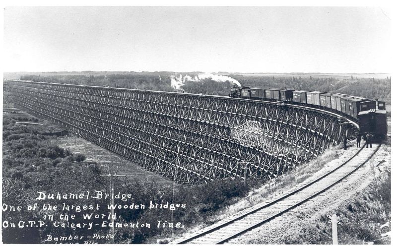
The Duhamel/Battle River rail bridge was one of the largest wooden rail bridges ever constructed, at 3,972 feet (1210 m) in length and 120 feet (32 m) in height. In 1909 the Grand Trunk Pacific announced it would build a bridge across the river, and Duhamel quickly grew. Sadly, the bridge only stood for 14 years before the railway consolidated routes. The bridge was dismantled.
Today, Duhamel is a hamlet in the central Alberta, Canada within Camrose County. It is located on Highway 21, approximately 100 kilometres southeast of Edmonton and 20 kilometres southwest of Camrose, Duhamel’s closest major trading centre. In the 2021 Census of Population conducted by Statistics Canada, Duhamel had a population of 46 living in 17 of its 18 total private dwellings. The hamlet of Duhamel is a quiet rural community with an access to the bottom of the river valley where people can go canoeing, hiking and snowmobiling. The Verdun School and St. Thomas Church (built-in 1883) near Duhamel are beautiful historical resources worth visiting.
Address
Community: Duhamel
Province: Alberta
Map Location
Latitude, Longitude
52.916578, -112.965201
Map Location
| Surname | Given Name | Book Title | Call No. | Page No. |
|---|---|---|---|---|