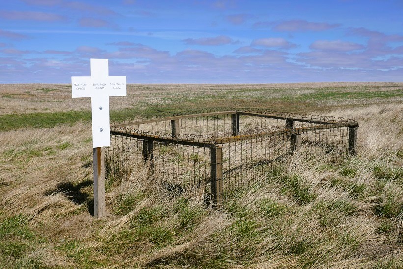
The Adam Wolfer Family Cemetery, Sandy Point, Alberta, is located five and one half miles west and four miles north of Burstall, Saskatchewan, one mile north of Township Road 202, on Range Road II. This well fenced plot is in danger of being lost if the old Empress highway north is ever widened again. This tiny plot has been unattended for the past forty years, yet the wooden fence prevails.

Courtesy of Medicine Hat and District Genealogical Society (MHDGS)

Deaths

Longevity

Address

Twp Rd 202 & Rge Rd 11
Nearest Populated Centre: Sandy Point,
Province: Alberta

Map Location

Latitude, Longitude
50.70298, -110.02796

Map Location

Search for:
RESET
Surname Given Name Born Died Age Photo(s) Cemetery Obituary Narrative R Code

The 25 most common surnames found in this cemetery.

loader

The 25 most common given names found in this cemetery.

loader

Other Cemeteries

Pine Creek Cemetery (Foothills County)

220 Legacy Village Link SE , Calgary , Alberta

East Olds Baptist Cemetery (Mountain View County)

Highway 27 (east of Olds) , Olds , Alberta

Neuburg Adventist Cemetery (Cypress County)

Twp Rd 101 & Rge Rd 32 , Neuberg (south of Irvine) , Alberta

Dalby Cemetery (Wetaskiwin County)

46130 Range Road 274 , Falun , Alberta

Granum Cemetery (MD of Willow Creek)

Highway 19 and Service Road 2 E; next to Highway 2 , Granum , Alberta

Strathmore Cemetery (Wheatland County)

Westridge Road; adjacent to Hwy 1 , Strathmore , Alberta

Coleman Union Cemetery (Crowsnest Pass)

27 Ave & 28 Ave , Coleman , Alberta

Lille Cemetery (Crowsnest Pass)

Lille , Lille , Alberta

Coleman Catholic Cemetery (Crowsnest Pass)

77 St & 27 Ave , Coleman , Alberta

Sunnynook Cemetery (Special Area No. 2)

Township Road 272 E of Range Road 124A , Hanna , Alberta

Discover Alberta Ancestors