
Range Road 513 S of Cessford
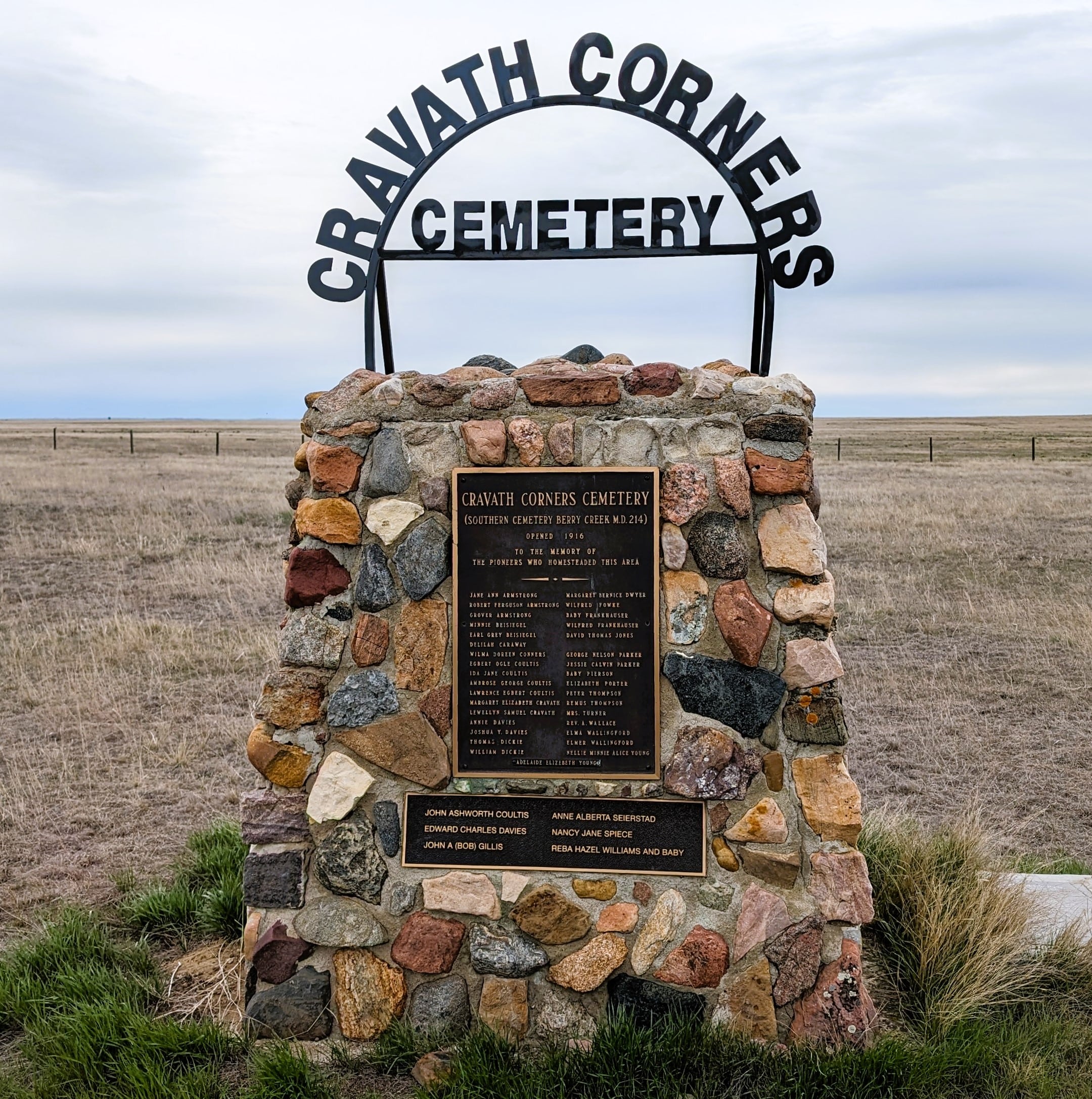
A history of Cravath Corners was written by Margaret E. Bell and Mrs. Emil Sandgathe. The Cravath Corners Cemetery serves Wardlow, Steveville, Cravath Corners and Howie districts. It is located at NE 09-22-11 W4, about 8 miles east and 2 miles south of Wardlow. It is a cemetery of mainly unmarked, unnamed graves. In 1976 local residents, with the aid of an Alberta Government grant, erected a cairn bearing the names of 34 pioneers and their children interred there. The original records of the cemetery were lost, hence the list of names on the cairn is only approximate.
It was first settled in 1910 by Mr. and Mrs. J. Cravath, Mr. and Mrs. Ed Bell, Mr. and Mrs. Walter Kin and Mr. and Mrs. Milo Cravath. They each bought a section of land with adjoining corners. Each of the four families had a member of the Cravath family in it. Hence, the name Cravath Corners was given to the post office started by J. Cravath. Mrs. J. Cravath died in 1914. Mr. J. Cravath moved away in 1919. Mr. and Mrs. Bell moved to Bassano in 1921, Milo and Betty Cravath left in 1926. The post office was closed and Cravath Corners ceased to exist. (*Excerpt obtained from ‘This Is Our Land, A Centennial History’).
The first interment in 1916 was that of a young homesteader, David Thomas Jones, who suffocated in his shack. Here also lie the 2 Parker brothers, George Nelson and Jesse Calvin, both with young families who died within days of each other of influenza epidemic that followed World War 1. Also buried here was a young homesteader, Peter Thompson, who drowned in the Berry Creek south of Wardlow at a place long since known as the Thompson hole. An infant son is in the same cemetery.
Address
Range Road 513 S of Cessford
Nearest Populated Centre: Wardlow,
Province: Alberta
Map Location
Latitude, Longitude
50.8628, -111.45927
Map Location
| Surname | Given Name | Born | Died | Age | Photos | Cemetery | R Code |
|---|---|---|---|---|---|---|---|
The 25 most common surnames found in this cemetery.

The 25 most common given names found in this cemetery.