
Twp Rd 132 (Longvalley Rd) east of Range Rd 33
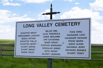
This cemetery is located northeast of Medicine Hat, six miles east of Highway 41 just east of Range Road 33 on Township Road 132 (Longvalley Road). The plans for a church at this location were in place but the building was never constructed. All the records were written in German, and the minutes of the trustees were lost. The land was donated by N. Stehr, and the certificate of title was held at the registration office at Calgary, Alberta, is in the names of John Geigle, Emanuel Jeske and Gottlieb Boes as trustees. The first burial was recorded as of October 1918, a child of Ferdinand Oberhammer, with subsequent burials in 1923, 1924 and 1925. However it must be noted that registration of title did not take place until at least 1924, as that was the year Mr. Jeske first moved to the area. The last burial took place in November, 1944, the deceased was from the Finn’s lake area. Nick Stehr was for many years the recording secretary and treasurer. Upon his retirement in 1947 the records were taken over by Emil Jeske, who soon after left this area and has passed away. The burial records were returned and are presently held by T. Stehr, but the minute book was not and therefore the names of first or last board of directors is not available. In the absence of a board of trustees, the cemetery is kept in a reasonably clean state by the T. Stehr family. This small plot has been cared for by three generations of the Stehr family, Traugott Stehr has passed the maintenance of the plot to his son Stanley Stehr who lives nearby. Traugott’s father donated this piece of real estate about eighty years ago. This site was never occupied by a church building, the cemetery was used by various denominations. As at September 02, 1996, the fence was in good order, all posts are painted white, the grass is neatly trimmed and the Stehr family has marked each grave with small white crosses. They have also erected a wooden cairn which lists all those interred here.
Information courtesy of Medicine Hat and District Genealogical Society (MHDGS)
Address
Twp Rd 132 (Longvalley Rd) east of Range Rd 33
Nearest Populated Centre: Irvine,
Province: Alberta
Map Location
Latitude, Longitude
50.07691, -110.34504
Map Location
| Surname | Given Name | Born | Died | Age | Photos | Cemetery | R Code |
|---|---|---|---|---|---|---|---|
The 25 most common surnames found in this cemetery.

The 25 most common given names found in this cemetery.