
28139 Twp Rd 320
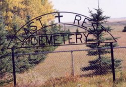
Last Rest Mennonite Cemetery, also known as My Last Rest Mennonite Cemetery, is located 25 km northeast of Didsbury. As of 2022, the cemetery has 50 interments.
Town of Didsbury
The Town of Didsbury is located next to Alberta Highway 2A, near the Queen Elizabeth II Highway. Didsbury is approximately the half-way point between the cities of Calgary and Red Deer.
The town is named after the township of Didsbury, now a suburban area of Manchester, England. The first settlers were German Mennonites who left their homes in Pennsylvania following the American Revolution and emigrated Waterloo County in Ontario. They were granted the area around Didsbury in 1894 by the government of Sir John A. Macdonald.
Original settlement in the area was sparse, and this in part explains the initial slow development of the town-site as a service centre. The first concern of the Mennonite settlers was to build a church; and the primary task of the settlers was to create farmsteads. Settlement prior to the post-1900 land rush was limited to the small group who came west in 1894.
1897 saw the arrival of the Canadian Pacific Railway, which pushed forward the town’s development. The CPR constructed a station in the town in 1904. Didsbury was incorporated as a village in 1905 and as a town on September 6, 1906.
Fires in 1914 and 1924 destroyed the early “boomtown” commercial streetscape and led to the passing by Town Council of a bylaw which required masonry construction for all new downtown commercial buildings. Many of these brick buildings stand today.
Source: https://en.wikipedia.org/wiki/Didsbury,_Alberta
Address
28139 Twp Rd 320
Nearest Populated Centre: Didsbury,
Province: Alberta
Map Location
Latitude, Longitude
51.70692, -113.86679
Map Location
| Surname | Given Name | Born | Died | Age | Photo(s) | Cemetery | Obituary | Narrative | R Code |
|---|---|---|---|---|---|---|---|---|---|
The 25 most common surnames found in this cemetery.

The 25 most common given names found in this cemetery.