
Eagle Butte Rd & Township Rd 74
This fully restored church is located in Medicine Lodge Coulee in the west Cypress Hills. The church is one mile south of the “divide”- water below the church runs into Medicine Lodge Creek which in turn leads into the Milk River system then into the Missouri and Mississippi rivers and on into the Gulf of Mexico. Water to the north of Eagle Butte empties into the South Saskatchewan River, Hudson Bay and the Atlantic.
The Cypress Hills were holy hills for the First Nations Peoples. They called them the “Thunder Breeding Hills.” The following bands were known to frequent the area; Blackfoot, Blood, Piegan, Gros Ventre, Assiniboine, Cree, Crow and Sioux. The hills were a favourite haunt of the Metis as well as of White traders. It was part of the historic trade highway from Fort Benton, Montana – the head of steamboat travel to the upper Missouri – leading on to Battleford, North West Territories (now Saskatchewan) the seat of the territorial government.
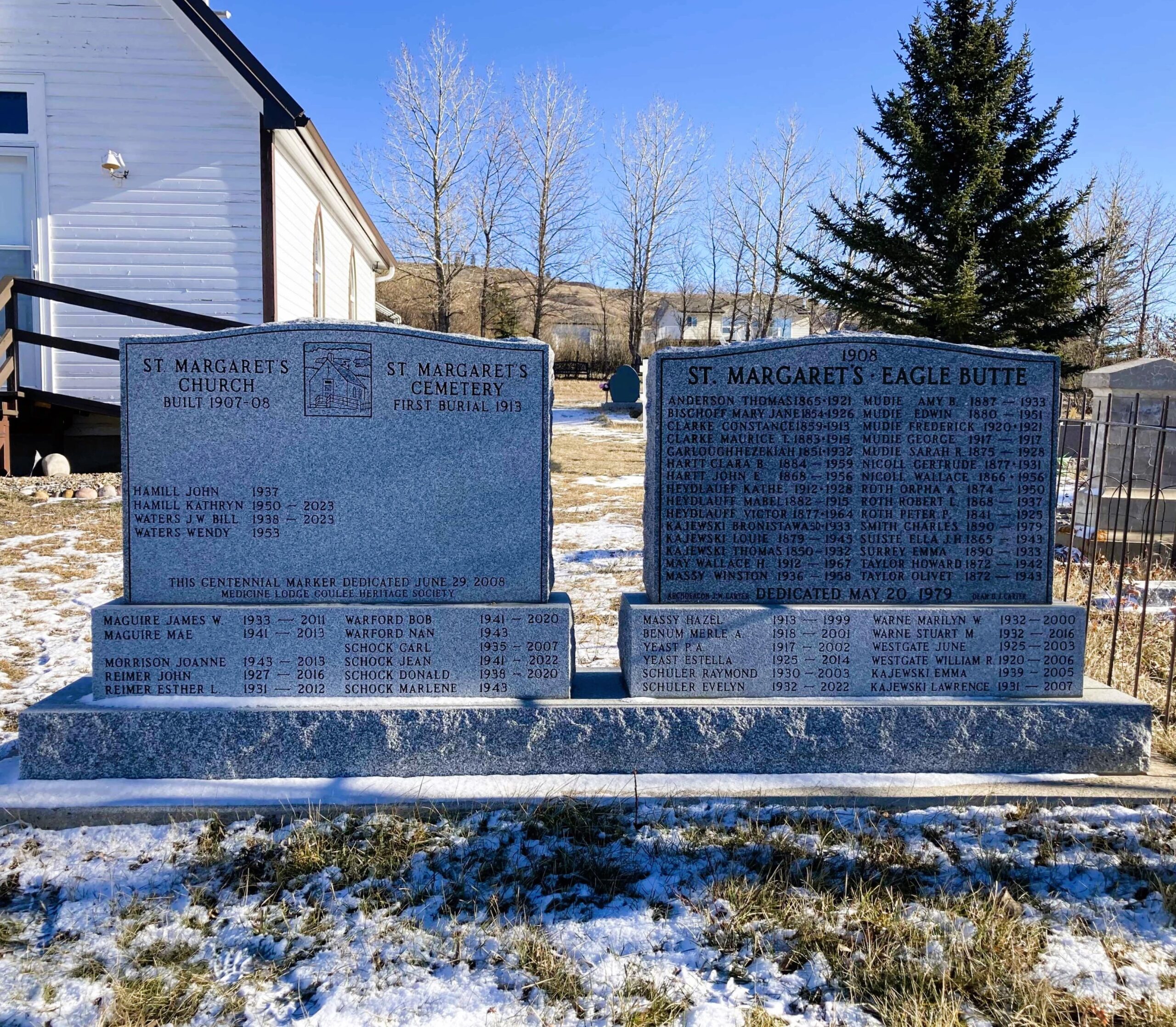
Canon George McKay of the Church of England held services at Fort Walsh in 1878 or shortly thereafter. Regular services were held from 1883 in the Cypress Hills. Churches were built north of the Hills – St. Anne at Josephburg in 1897, St. Alban at Gros Ventre/Tot Hill in 1904, St George at Irvine in 1907 and St. Margaret’s on July O8, 1908. The church was opened June 28, 1908.
The forty acre parcel of land on which the church stands was donated by Harry Mudie. Title was registered to the Synod of the Diocese of Qu’Appelle at Regina, Saskatchewan, October 1907. Construction of the church occurred from 1907 to 1908. The church was dedicated to St. Margaret in memory of Margaret Louise, eldest daughter of Cyril and Hanah Muskgrove. Margaret died December 15, 1897, of pneumonia at age fourteen.
Church services at St. Margaret’s were held in the summer with clergy coming first from Irvine, Alberta, then later from the Medicine Hat, Alberta, churches of St. Barnabas or Holy Trinty. The last regular services were conducted by Archdeacon J.W. Carter in 1969.
In the early 1940’s the church was used as a school house after the district school burned down. It was probably cold inside as there was neither insulation nor electricity. In 1976 the Diocese of Calgary sold the property to the Very Reverend D. Carter. Work parties are held each Canada Day weekend to maintain the church and cemetery. In 1992 a complete renovation took place, insulation and electricity were installed. The original baptismal font was located. The altar is from an abandoned church at Coutts, Alberta, the altar cross from the abandoned church at Grassy Lake, Alberta, the lectern was used in the Orion, Alberta, area and the stove came from Milk River, Alberta. A non-profit society has been formed to administer the site.
The church and cemetery are located in the north-west corner of SE 20-07-03-W4. The memorial marker was dedicated May 20, 1979. The grounds are well groomed and all buildings and fences are in very good condition as at September 7, 1996. The location can be found by travelling south of Medicine Hat, Alberta, on the Eagle Butte Highway, through the Cypress Hills, one half mile south of Township Road 74 then one quarter mile east.
Courtesy of Medicine Hat and District Genealogical Society (MHDGS)
Address
Eagle Butte Rd & Township Rd 74
Nearest Populated Centre: Eagle Butte,
Province: Alberta
Map Location
Latitude, Longitude
49.58151, -110.37172
Map Location
| Surname | Given Name | Born | Died | Age | Photo(s) | Cemetery | Obituary | Narrative | R Code |
|---|---|---|---|---|---|---|---|---|---|
The 25 most common surnames found in this cemetery.

The 25 most common given names found in this cemetery.